


The population of Karachi is considered a megacity of Pakistan, and traffic here always remains jam-packed, particularly during peak hours. The situation during a traffic jam is a nightmare and also increases the traveling time between two points of a city.
There is a famous metropolitan region in Karachi that needs a mass transportation system to avoid the terrible traffic conditions that most people face on the daily basis.
To add some solution to the above problem, “Lyari Expressway, Karachi” was initiated in 2013. Now it has become one of the most favorite additions to the solution for public transportation in a convenient and cost-friendly way.
In this article, you will find Lyari Expressway, Karachi – Complete Route Guide, and much more. People can also contact Sindh “National highway and motorway police” for the Lyari Expressway helpline to know more details.
History
Lyari expressway, Karachi, the project was launched back in 2002 it aimed to serve the public in the form of the commuting artery that connects the M9 motorway and Mauripur road. it was expected that the project will take only thirty months, but it take much more time and the road was completed at the end of 2007.
Due to a lack of funds, Lyari express was stopped but in 2016, Govt introduced funds for its completion, and finally Lyari Express started in 2017.
Route and Directions
Lyari Expressway route is 38 Km long and takes people from one end of the city to another end and ultimately helping to reduce the travel time between different city points. Where people reach in hours now can reach in minutes through Lyari Expressway.
Lyari Expressway is a two-way project with a multi-lane that connects the almost entire city with various entry and exit points where each of the points ends on a toll plaza with a nominal city fee.
As the Lyari expressway is along the riverside in Karachi, that’s why therefore heavy and two-wheel vehicles are not to enter in Lyari Expressway.
Here is the Lyari Expressway route guide.
From its starting point (M9 motorway) to its destination point (Mauripur road), there are the following entry and exit points in the Lyari Expressway.
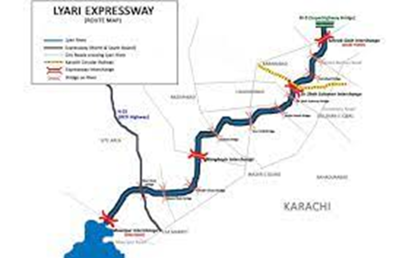
Starting point (“Sohrab Goth interchange”)
It is the starting point of Lyari Expressway that is also used by the traffic that follows the Shahrah e Pakistan route and also the outside city traffic can use it to continue their journey. It acts as an exit point for the traffic that comes from the opposite direction. The maximum speed allows in this urban area is 80 Km per hour.
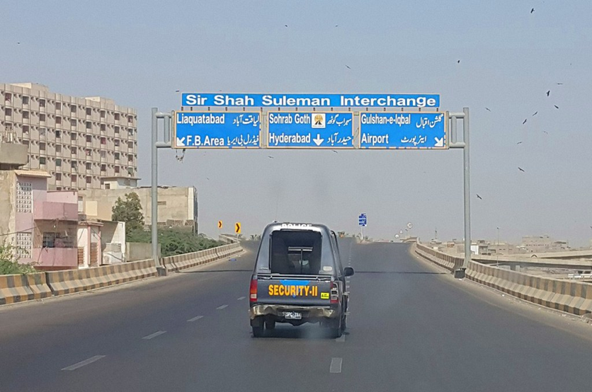
Sir Shah Suleman Interchange
This point which is both entry and exit is located near “Liaquatabad” and nearby there is ”Sir Shah Suleman interchange” and their area is known as the “Gulshan e Iqbal Town”. So, the people who want to visit the National Stadium, Karsaz, and Gulistan e Iqbal, should exit from the Lyari expressway.
Mangopir road
The next point on this signal-free expressway road is U-turn and toll plaza which is located near Mangopir road. Near there is an interchange. People who have a destination point in the Saddar town, garden, or in the surrounding area can take off from the Lyari Expressway.
Mauripur road
It is the end of Lyari Expressway road as well as the begging point for traffic from the opposite direction. From this point, people can travel towards keamari, the routeing hub, estate Avenue through gulbai flyover, and the northern bypass.
Keep traveling in the forward direction if your destination point is in one of the beautiful beaches of Karachi, for example, manora beach resort, and Hawke’s Bay.
End Note
In this article, you will find all the details about the Lyari Expressway, Karachi. Also, complete details about its route are given in this article. In case of queries, you can contact Lyari Expressway by using their helpline.